
YARRA RIVER
Author - Thomas Elms
Yarra River Water level http://www.bom.gov.au/cgi-bin/wrap_fwo.pl?IDV60154.html#Yarra_Catchment
or
https://www.melbournewater.com.au/water/rainfall-and-river-levels#/reader/229200B
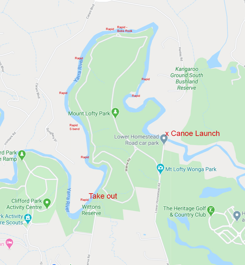
Homestead Rd to Wittons Reserve
Potentially one of the most difficult sections of the Yarra river, this trip should not be attempted by beginner kayakers and never alone. An ideal water level for this section taken from the Warrandyte gauge is anything over 0.8m. The river can become very fast and unpredictable when water exceeds 1.5m and can increase the risk substantially.
Entry to the river is via the Lower Homestead Rd carpark, there is a concrete boat ramp ideal for launching kayaks.
After a 10-15-minute flat water paddle the first section of rapids are reached, but the main feature of the river is another 10-minute paddle further downstream. “Bob’s Rock” is the largest feature of this section, identifiable at most water levels as a large boulder sticking above the water. The easiest line at most water levels is the close left hand side of the rock which sets paddlers up nicely to either stop in the left-hand eddy or continue downstream.
The other notable feature on this stretch is the “S-bend” rapid, which is a further 10 minutes downstream of Bob’s rock. Following the left-hand bank leads to a small drop that takes paddlers to the right-hand side of a large island, be careful of low hanging trees in this section as depending on water levels they can be potentially hazardous.
The final section of this run takes paddlers through several smaller features until a large straight, flat section of river is reached. The exit point is at the Wittons reserve carpark, on the river left where there is a large set of steps for an easy exit.
Driving back to the start ramp only takes 10 minutes, however it is a 20-30 minute walk over the hill through Mt Lofty Park back to the Homestead Rd carpark. This route can be difficult due to very steep tracks and potentially the weight carrying boats but is very accomplishable.
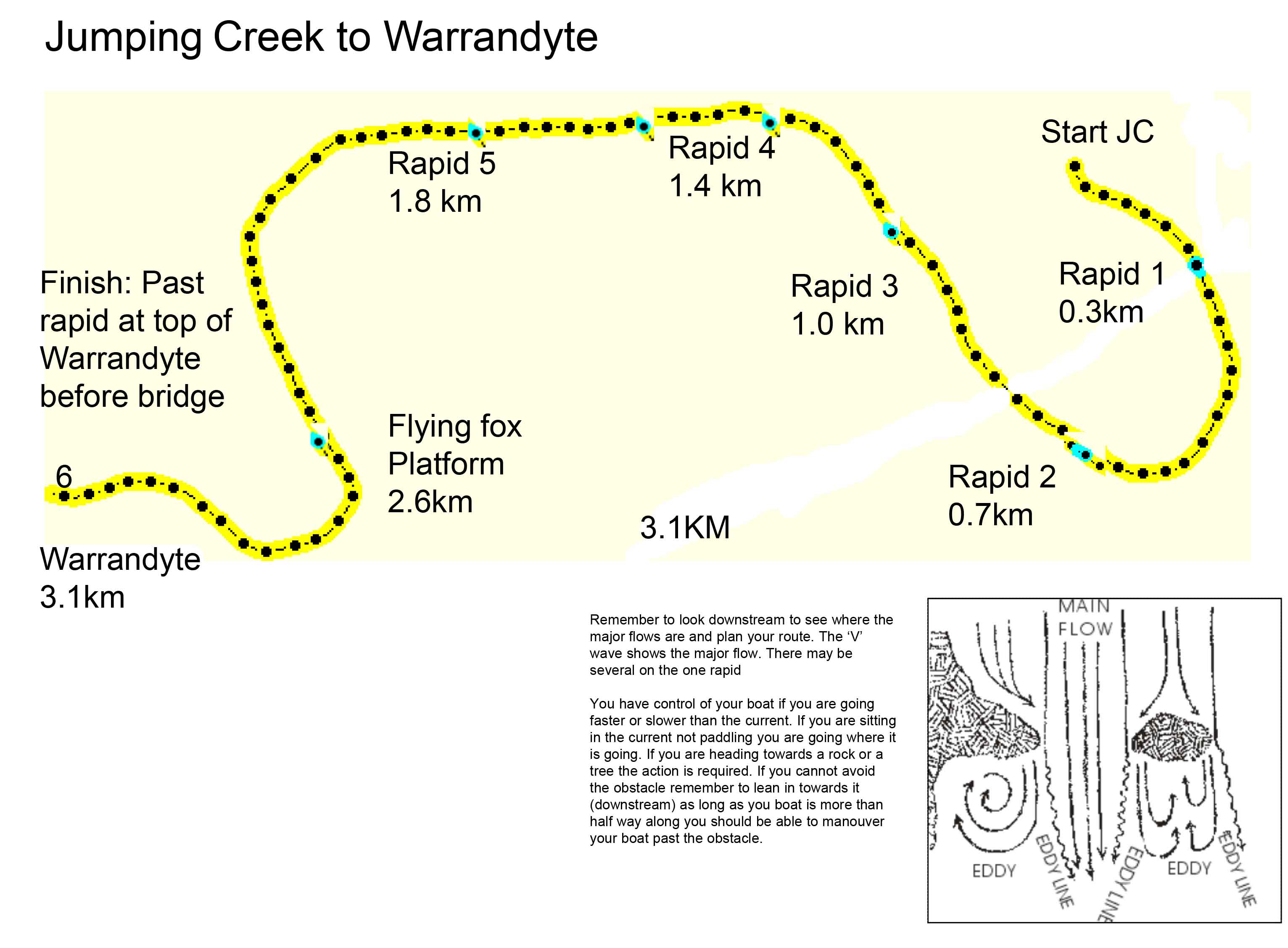
Jumping Creek Reserve to Warrandyte
This stretch of river is very suitable for beginner paddlers and provides an excellent introduction to rapids and basic river navigation skills. An ideal water level taken from the Warrandyte gauge is above 0.7m and anything over 1.2m at Warrandyte makes it washed out.Access to the river is at Jumping Creek Reserve where there is a large stretch of riverbank making entry very easy. At regular river levels there are no particularly large features, however throughout this trip it is always important to stop to look at any rapids before making your way down, as well as keeping an eye out for potential hazards including low hanging branches and fallen trees in the river. The run is broken up be a series of small pebble races and a few larger chutes that are reasonable continuous throughout. The most technical rapid is at the conclusion of the paddle and is reached as paddlers enter Warrandyte. Be careful of large sharp rocks, at low levels this section can be difficult to navigate without scraping or hitting anything.
Exit from the river is above Warrandyte bridge along the left-hand riverbank and is in sight of the large carpark for an easy shuttle.
The entire journey can take anywhere from 30 minutes to an hour depending on water level and craft and generally makes for a very enjoyable afternoon river trip.
Warrandyte to Pound Bend
This section of river is suitable to paddlers of any skill level and is ideally paddled at river levels over 0.8m at Warrandyte. Access to the river is above the bridge in Warrandyte using the large rocks that are lined along the left-hand riverbank to assist with entry.
A mostly flatwater river section, the largest feature can be found at normal water levels at the end of Police Rd in Warrandyte, 15 minutes into the paddle.
Just under halfway through paddlers reach the pound bend tunnel
DO NOT ATTEMPT AT ANY WATERLEVEL
The tunnel can be extremely hazardous because of both how narrow it is and the large numbers of rocks and branches along it. The darkness makes it extremely difficult so see submerged obstacles and the risk of becoming pinned or injured is extremely high. Paddlers should also be careful of getting too close to the entrance, at high water levels there is a very high flow going through and it is potentially very easy to get sucked in.
The rest of the trip is mainly flatwater broken up by pebble races. Paddlers should be wary of fallen trees and submerged branches as this section is particularly susceptible to fallen trees blocking the river creating a large risk. Basic water reading skills are required to navigate the rapids and obstacles.
The get out point is at the exit of the pound bend tunnel, where there is a small beach and boulder garden to make getting out of boats very easy. A large carpark is within sight of the finish making a car shuttle very easy.
Sweeny’s lane to Westerfolds
A very enjoyable section of the Yarra, Sweeny’s lane to Westerfolds is ideal at 1.0m taken from the gauge at Warrandyte and still enjoyable down to 0.6m.
River entry is at the end of Sweeny’s lane in Eltham where there is a large dirt carpark with a view over the river. This hour-long paddle has three main features along the way, the first of which being the largest and starts just around the corner of the first long straight. This rapid is best approached slowly and the line is along the left-hand river bank. Around the next corner is the next rapid, a fast-moving s-bend that requires little manoeuvring. After a large flat-water paddle, the Westerfolds slalom rapid is reached and paddlers can exit either above or below this rapid, as there is a carpark and boat ramps at both ends.
Westerfolds to FinnsEntry can be either above or below the Westerfolds Slalom Rapid, using the carparks available as this does not affect the duration of this trip, taking anywhere from 45 minutes to over an hour.
A more technical section of the Yarra, beginner paddlers may struggle with navigating certain rapids. This stretch of river can be completed at any water level, however, is most enjoyable at around 0.8 taken from the gauge at Warrandyte.
The largest and most technical feature is encountered at the end of the long flat straight at the beginning of the river trip, following the river around to the left. This rapid can be very difficult especially at low water levels. The line is very technical and requires intermediate water reading and paddling skills. It should always be scouted before descending as sticks and branches frequently get trapped along the way further contributing to its difficulty. The rapid washes out at river levels over 1.2m and is at its most difficult at 0.6-0.7m.
A fun chute around the next corner leads to a long flat section of water, being broken up by small pebble races and other features. This continues until paddlers reach the conclusion of the trip, reaching the yellow suspension bridge over the river at Finns reserve. The rapid below the suspension bridge is extremely rocky and can be very difficult to navigate at low water. It is approached along the river left hand bank, next to a large log in the water. Paddlers should descend slowly, as the many rocks make the risk of getting stuck quite high, moving to the left-hand side of the island below the bridge if possible.
Exit from the river is on the river left just around the corner out of sight of the bridge, where large stone steps make exit from the river at any level very easy. The Finns reserve carpark is within sight of the river, making a car shuffle very easy. This stretch of river can be extremely technical and should not be attempted alone.